LEAVE NO WATERS
UNCHARTED
The future of digital charting has arrived.Create richly detailed maps of your favorite fishing
spots in real-time with Humminbird’s AutoChart® Live, a free feature available with all GPS-equipped
SOLIX and HELIX G2 / G2N and newer models. Map the water as you drive the
boat and keep the data stored on your fish finder or import it into the AutoChart PC program.
No subscriptions. No hidden fees. No need to submit your data and wait for a finished chart.
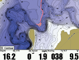
Once your map is live, view it with vegetation, bottom hardness and depth contours to locate the best fish-holding areas.
CHART MORE DETAIL
WITH EVERY PASS
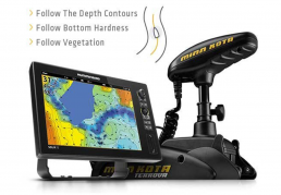
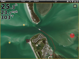
AutoChart Live gives anglers the ability to map depth contours,
aquatic vegetation and changing bottom hardness. This “trifecta” of information is critical to
finding fish as they relate to depth, weed lines and transition points in bottom type.
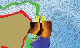
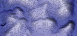
DEPTH
CONTOURS
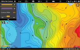
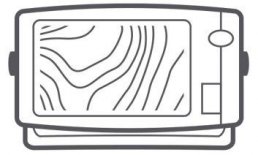
With a major assist from your transducer, AutoChart Live draws a map of your lake’s depth contours – complete with actual depth labels – as you drive your boat.
BOTTOM
HARDNESS
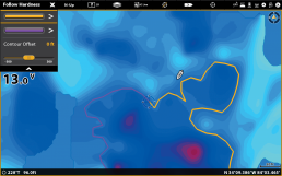
Now the detail goes even deeper. AutoChart Live uses sonar to measure and chart bottom hardness, tipping you off to likely hotspots.
VEGETATION
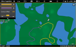
The weedline can no longer hide. With help from your sonar beam, AutoChart Live can now instantly map weeds, brush and other vegetation.
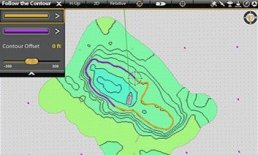
LET i-PILOT LINK NAVIGATE FOR YOU
i-Pilot® Link™ enables your Humminbird fish finder, Minn Kota® trolling motor and custom-made AutoChart map to work together. Simply instruct your Humminbird to “Follow” a depth, bottom hardness or vegetation contour line for automatic boat control.
SIDE IMAGING MOSAIC
Once you’ve created your new maps, import to your computer and overlay them with Side Imaging® or 360 Imaging® to create a custom, detailed view.
STORE & SHARE
Humminbird units with AutoChart Live come equipped with up to eight hours of internal recording time. For years of recording, you will need to purchase a ZeroLine SD Card. This card lets you record, export and share your favorite fishing spots, if you’re into that sort of thing.
PERFECT FOR SALTWATER
AutoChart Live is ideal for the ever-changing contours of Saltwater. Map artificial reefs, moving tidal cuts and channels with up-to-the-minute accuracy.
CREATING YOUR
CHART IS SIMPLE
Step 1: Make sure you have the latest software
If you have a GPS-equipped SOLIX or HELIX G2/G2N or newer model you are ready to start charting depth, vegetation and bottom hardness levels.
Step 2: Turn it on and Go
From any chart view, choose menu and select the AutoChart Live tab. Press record and you’re ready to make a map. Now start driving back and forth over the water, as if you were mowing your lawn.
Step 3: Your Map Appears
Watch your own AutoChart Live map appear before your eyes, live on your screen. You now can begin using exclusive Humminbird LakeMaster features and i-Pilot Link “Follow”.
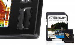
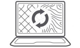
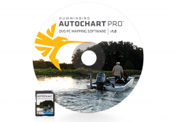
AUTOCHART PC
AutoChart™ uses your Humminbird sonar returns and GPS to build customized charts. Simply record that information onto an AutoChart Zero Lines map card (included), import that data into the AutoChart PC program, and convert it into a lake map. Once completed, transfer your custom map back onto the AutoChart Zero Lines map card for display on any compatible Humminbird, including select SOLIX, HELIX, ONIX, ION, 1100, 900, 800, 700 and 600 Series models.
RECORD SURVEY DATA
Travel back and forth then up and down water in a zig-zag pattern with your Humminbird in record mode.
CONVERT YOUR DATA
Transfer the saved survey data from your Humminbird to your PC via the AutoChart Zero Lines map card (included). AutoChart will convert that data into a detailed map.
EXPORT YOUR MAP
Save the newly created map back onto your AutoChart Zero Lines map card for use in your Humminbird.
i-PILOT LINK COMPATIBLE
3D VIEWS
AERIAL PHOTOGRAPHY OVERLAY
AUTOCHART PRO
Add another layer of detail to your AutoChart cartography. AutoChart PRO offers the leading features of AutoChart but with two key enhancements designed for tournament anglers. Bottom Hardness Indication delivers a crucial tip-off to where fish are hiding, while Side Imaging Mosaic allows you to overlay your Side Imaging returns onto your AutoChart map for a 3D visualization of fish-holding habitat.
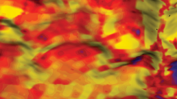
BOTTOM HARDNESS INDICATION
Identify areas likely to hold fish based on the hardness of the bottom. Exclusive to AutoChart PRO.
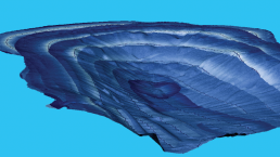
SIDE IMAGING MOSAIC
Overlay Side Imaging returns onto your map for a 3D visualization of contours. Exclusive to AutoChart PRO.